Your word is a lamp unto my feet and a light for my path. I have taken an oath and confirmed it that I will follow your righteous laws. Psalm 119:105,106
Paul traveled to cities on two continents. God always drew the map. God mapped out Paul’s journeys and Paul followed it even when he did not know where it would take him. God has a map for our life on which he has marked our starting point and the finish line. The map begins with our birth and ends in heaven. In His Word, He lists the standard map symbols for us to follow. Use them often.
Whether you are walking across town to meet with your best friend or traveling with your dad on a super highway to go fishing at a new lake, some kind of map is needed. If you have been to your friend’s house often enough, the “map” will be in your head. You know that Jimmy lives at 5th and Elm and you know how to get there. But when looking for a new lake, all you know is that the lake is outside of Midville on Highway C. Unless you have been there before, you will have to rely upon a map to show you the way.
DEFINITION OF A MAP
A map is a two dimensional representation of the world we live in. Maps can show towns, highways, boundaries and many other details. One of the most useful maps for the outdoorsman is a topographic or topo map.
TOPOGRAPHIC MAP SCALE
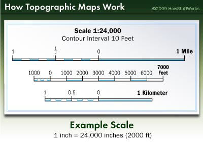
Another thing you need to understand about a topographic map is scale. Obviously, maps aren’t life-sized. Otherwise we’d never be able to fit them in our backpacks. Instead, cartographers plot maps on a ratio scale, where one measurement on the map equals another larger amount in the real world.
The first number of the scale is always one. It’s your unit of measurement, usually an inch. The second number is the ground distance. For example, if your U.S. Geological Survey (USGS) map has a scale of 1:24,000, it means that one inch on the map is equal to 24,000 inches (2000 feet or 609.6 meters) in the real world. Your map’s scale legend will always be at the bottom.
For USGS topographic maps,
1:24,000 is the scale most often used. Maps based on metric units use a scale
of 1:25,000, where one centimeter equals 0.25 kilometers. You’ll find most of the
United States mapped at the 1:24,000 scale,
with only a few exceptions. Puerto Rico, for example,
maps at 1:20,000 or 1:30,000
because the country
originally mapped at a metric
scale. A couple of
states map at 1:25,000, and most of Alaska (due to its size) maps at 1:63,360. The more populated areas of Alaska, though, map at
the typical 1:24,000 or 1:25,000.
A 1:24,000 map is large and provides a lot of detail about the area — it will include buildings, campgrounds, ski lifts, among other things. You may also see footbridges and private roads on a map of this scale.
It requires about 57,000 maps at this scale to cover the 48 contiguous United States, Hawaii and territories [source: USGS]. However, you can find maps of various areas at all different scales. The scale corresponds to its intended use. For example, township engineers generally need extremely detailed maps that show sewers, power and water lines, and streets. The common scale for these maps is 1:600. If you want to see one large area on a single sheet but with less detail, a smaller scale map like 1:250,000 is better.
MAP COLORS
There is much information that can be obtained from a topo map. Starting at the bottom is the scale, the survey date, the magnetic declination and the map’s location with respect to the entire state. The map itself is drawn in five colors:
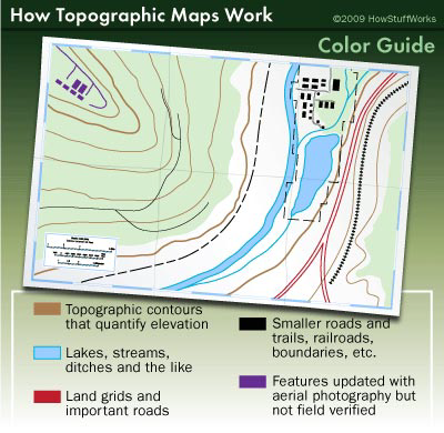
BLACK Man made objects (highways, buildings, railroads, power lines, etc.)
BLUE Streams, rivers, lakes, etc.
BROWN Contour lines showing elevation
RED Some major highways and boundary lines
GREEN Woods and forests
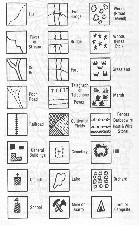
MAP SYMBOLS
An explanation of some of the symbols is shown below.
USING A TOPO MAP
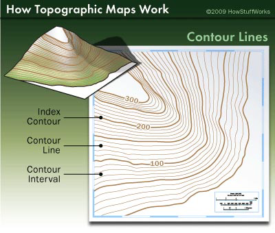
Laying a topo map out on a table, you can use a ruler to find the distance between any two points. Studying the contour lines, you can find steep cliffs, valleys and gently sloping hills (see the figure below) If you have a topo map of your area, take it outside and line it up with your surroundings. Looking around you, find a highway or a railroad or a tall hill and then locate it on the map. Do this several times to familiarize yourself with how the map represents your area. Looking only at the map, can you “see” your surroundings?
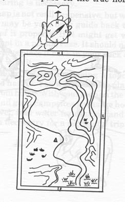
To be able to use a map effectively, you will need a compass. To orient your map to true north, study the figure to the right. Place your compass on the
true North indicating arrow at the bottom of the map. Turn the compass and map together until the compass needle aligns with the map’s magnetic north line. (This works if the map is of your present location.
If the map is of an area that has a different magnetic declination than your own, it is aligned to true north using your local declination, not of the map.) The map is now orientated to true North and the map details will coincide with the ground details. Now, if you know where you are on the map, you can find the direction to any other point and how far away it is by using your
compass and the built-in scale.
One thing to remember about a topographic map is that north will always be at the top edge of the map. You might notice other maps shift north around in order to make the map fit better on the page. With topographic maps, though, rest assured that north will always be in the same place.
Level 1 Requirements:
- Define the following terms:
- Map
- Symbol
- Draw and identify on a topo map the symbols for each of the following:
- Marsh
- Road
- Railroad
- Stream
- Lake
- Buildings
- Woods
- Spring
- Telephone line
- Trail
- Align a map to North using a compass.
- Define the following terms:
- Latitude.
- Longitude.
- Explain the term:
a. Contour lines.
- Explain what a topographic map is and demonstrate its use.
- Explain what a map scale is and demonstrate its use.